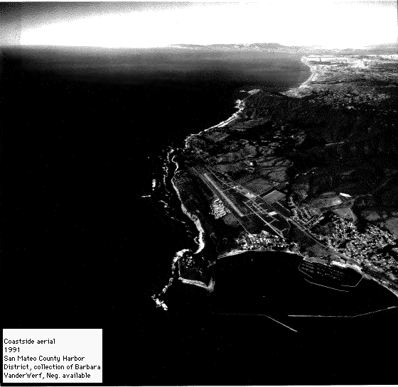
Looking north along the San Mateo County coast to San Francisco. Montara Mountain, the signature mountain of the Coastside, rises serenely out of the Pacific Ocean. [Courtesy San Mateo County Harbor District]
Want to find out more about the San Mateo County coast? Then take a look at three books which explore the coastal bluffs, Montara Mountain and the Coastside's past. All three were written by geographer and naturalist Barbara VanderWerf, San Francisco and San Mateo County resident for over 25 years.

Montara Mountain describes the trails, plants and history of the mountain, which is the center of the Devil's Slide bypass / tunnel controversy. The proposed 4.5-mile-long bypass would bisect McNee Ranch State Park, destroying a pristine island of biological diversity. The tunnel alternative would let Montara Mountain -- a Bay Area treasure -- remain intact.
The book leads hikers and bicyclists along both gentle and rugged trails to discover old roads which once connected San Francisco to the Coastside, a 175-foot waterfall, hillsides of spring wildflowers, and breathtaking ocean views.
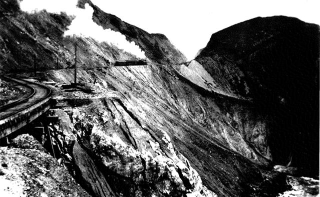
A brave Ocean Shore Railroad train crosses San Pedro Mountain in 1910. Today we call the same route Devil's Slide. [Courtesy Will Whittaker]
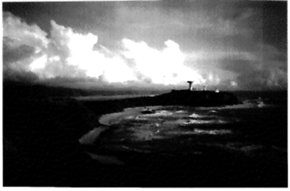
Nearly everyone has heard of Devil's Slide on Highway One around San Pedro Mountain, the ocean face of Montara Mountain. Here, from Montara Mountain, is how Devil's Slide got its name:
"Devil's Slide is a slippery name. Some folks apply it to the whole face of San Pedro Mountain -- from the pull-off for Stop 3 to the Highway One Saddle Cut adjacent to the massive promontory to the south. Others apply it only to the geologically unstable 1,000-foot-long section of ocean bluffs marked along the highway by caution signs and white concrete barriers."Montara Mountain offers plenty of old and new maps, recent and historic photographs, line drawings of plants and animals, and highlighted paragraphs with interesting tidbits of information."However, the name Devil's Slide came into use long before anyone thought of building a railroad or a highway along these bluffs."
"Originally Devil's Slide meant only the promontory and its inland ridge. In the 1880s, travellers in horse-drawn wagons on the Half Moon Bay--Colma Road, which ran along the top of the ocean bluffs, paused to note the chute-like ridge ending in the massive rock dome. They thought it looked fit for a Devil's Slide and named it so."
"The Ocean Shore Railroad blasted through the ridge for its roadbed and called the notch the Saddle Cut. The railroad never used the name Devil's Slide for the landslide-prone section of San Pedro Mountain. It is only in recent times, with the building of Highway One across the unstable bluffs, that the name Devil's Slide has come to mean the ocean face of the mountain.
"Some maps use "Devils Slide" but most folks use "Devil's Slide." [Montara Mountain, page 16.]
176 pages. 64 photos. Maps and sketches. 1994.
ISBN: 0-9632922-2-6
To order:
Available exclusively at the Friends at the Visitor Center in San Pedro Valley Park.
Contact:
"...captures the intrigue of Montara Mountain..."
— Tom Stienstra, San Francisco Examiner
"...truly a gem."
— Mark Simon, San Francisco Chronicle
"A wonderful walk on a mountain! Bravo, VanderWerf!"
— Rick Eymer, San Mateo Times
The Coastside Trail Guidebook describes six miles of easy walking and bicycling along the edge of the Pacific Ocean, from Pillar Point to Miramontes Point on Half Moon Bay.
Not only is this book a guide to the shoreline, but also to the history of the Coastside. Particularly fascinating is the effect that the Pillar Point Harbor breakwater had on the El Granada ocean bluffs, which have receded 150 feet since the breakwater was built in 1959.
An early name for Pillar Point was "Snake's Head."
[Courtesy Barbara VanderWerf]
Here's a little bit about Pillar Point taken from The Coastside Trail Guidebook: Walk 1.
"All the people who have lived along the shores of Half Moon Bay have used Pillar Point. For thousands of years, Native American Costanos gathered shellfish at its base. Their old shell midden lies hidden deep in the marsh. From the 1790s through the 1890s, Spaniards, Mexicans and Americans grazed long-horned cattle on its ridge. In the 1860s, Portuguese whalers sighted passing Humpback Whales from its high point and then launched their whaling boats from Whalemen's Cove just below. Beachcombers still find fragments of whale bones in the sand. In the 1920s and 30s, Coastside farmers grew artichokes and peas on its crown. But no one built any structures on its windswept heights.The Coastside Trail Guidebook offers plenty of maps, recent and historic photographs, line drawings of plants and animals, and highlighted paragraphs with interesting tidbits of information."Today, it is hard to imagine how Pillar Point looked without its array of antennas and buildings. The first buildings went up during World War II, when Pillar Point was an observation post linking the Coastside to the Harbor Defenses of San Francisco. Underground bunkers built during the war still exist and are used for storage. After the war, the silhouette of Pillar Point changed even more. More buildings went up, along with missile tracking antennas.
"Rockets were even fired from Pillar Point. In the fall of 1967, the Air Force planned to launch seven rockets, each bearing instrument-laden weather balloons. Fog cancelled a few of the launches. The remaining ones generated enough noise and burning exhaust gases to upset most Coastside residents. At each launching, a five-foot-long rocket blasted upward in a fireball from the muzzle of the launch cannon. Within 128 seconds, the rocket thrust itself to an altitude of forty miles, released its weather balloon, and then disintegrated. The weather balloon slowly descended, transmitting information on wind, temperature and air pressure.
"Nowadays, there are no more rocket launchings. Instead, you can watch as the huge dish antenna rotates to track missiles fired from other places.
"A few specifications: The crown of Pillar Point is 175 feet above sea level. The large dish antenna is 80 feet in diameter; its tower is 120 feet tall." (Coastside Trail Guidebook, pages 9-11)
Want more information?
112 pages. 50 photos. Maps and sketches. 1995.
New and Expanded Edition
ISBN: 0-9632922-3-4
"...does a marvelous job of presenting the Coastside..."
— Steve Tracy, Half Moon Bay Review
"Don't leave home without this remarkably all-inclusive book."
— Rick Eymer, San Mateo Times
"...a handy guide easy to bring along on any stroll..."
— Beth Geisma, Loma Prietan, Sierra Club
"...expand your hiking experience into new dimensions...
— Rasa Gustaitis, California Coast & Ocean
Granada, A Synonym for Paradise: The Ocean Shore Railroad Years tells the story of what it was like to live in suburban tracts on the San Mateo County Coast, south of San Francisco, in the early 1900s. Californians by the thousands bought lots in newly laid out tracts along the line of the Ocean Shore Railroad, whose motto was "Reaches the Beaches." But few lot buyers built houses. This is the story of the few who did, the Coastside Pioneers.
Granada, the most magnificent of all the tracts along the line of the Ocean Shore Railroad, was designed by the famed landscape architect Daniel H. Burnham. Advertised to San Franciscans as "the future playground of the greatest good-time-loving people in the world," its curving tree-lined streets, proposed beachfront amusements and hillside pleasure parks attracted thousands of potential lot buyers, but few homebuilders.
In 1920, the Ocean Shore Railroad, unable to compete with Ford automobiles and to keep its trains running along the sliding cliffs of Montara Mountain at the edge of the Pacific Ocean, stopped running. Farmers then bought the well-sidewalked, but empty, suburban tracts along its line and planted artichokes and Brussels sprouts.
The book's historical and recent photographs, aerial photographs and old maps will guide you on journeys of discovery through the Coastside landscape as you seek out the traces of the Ocean Shore Railroad and the suburban tracts. The railroad with its roadbed and its depots and the tracts with their sidewalks, snug bungalows and eucalyptus trees shaped the Coastside landscape we move about in today.
Granada, A Synonym for Paradise: The Ocean Shore Railroad Years is the story of a place in time.
Granada, designed by Daniel H. Burnham, the father of the City Beautiful Movement, was to be "the future playground of the greatest good-time-loving people in the world," the San Franciscans who rode the Ocean Shore Railroad. [1946 aerial Courtesy of U.S. Geological Survey]
Here's more about a town called El Granada, taken from Granada, A Synonym for Paradise:
"The town of El Granada is on the Pacific Coast about twenty-five miles south of San Francisco. It sits a bit inland from both the ocean and Highway One, and right in the middle of the Coastside, a narrow, ten-mile coastal strip along the western edge of San Mateo County."El Granada, a quiet unincorporated town of about 3,500 people, is not a typical small town. It has no main street. Only a few resident-serving businesses line a forgotten railroad right-of-way. Travellers on Highway One bypass the town in their search for shops and restaurants. Most residents work elsewhere;north in San Francisco; east "over the hill," meaning not on the Coastside; south in Half Moon Bay, or west in PrincetonbytheSea.
"Residents value El Granada for being off the beaten path, for its banana-belt climate on a coast notorious for spring winds and summer fogs, for its mix of old and new houses, and for its harmonious setting of gentle hills, mature trees and gracious streets.
"Some time ago, I set out to understand why El Granada is not a typical Main-Street small town, and why residents value the town so deeply. I spoke with many people, and nearly every conversation turned to one question: Why was the town called El Granada? Those who knew Spanish pointed out that if granada meant pomegranate, it required the article la. If granada referred to the city in Spain, it needed no el.
"So, why was the town called El Granada?
"Actually, the official name is Granada, after the Spanish city. Granada was registered as a tract on November 18, 1907, with the County of San Mateo by its owner, Shore Line Investment Company. The "El" was added by the United States Post Office Department in January of 1909. The County of San Mateo still records property titles in the tract book for Granada, but sends property tax bills to the post office in El Granada, ZIP code 94018."
[Granada, A Synonym for Paradise, page 11]
208 pages. 131 photos. Maps and sketches.
Bibliography. Index. 1992.
ISBN: 0-9632922-0-X
To order:
Available exclusively from Midcoast Park Lands
"...worthy of notice..."
— Harre W. Demoro, San Francisco Chronicle
"...a rich account..."
— Matthew Brady, San Francisco Independent
"...highly recommended as a unique community and landscape history."
— Diane Donovan, Bookwatch
| Daly City |
| |
| Fort Funston Visitor Center, Golden Gate National Recreation Area | ||
| Pacifica |
| |
| Florey's Books | (415) 355-8811 |
|
| Pacifica Books | (650) 738-9000 |
|
| Bicyclery | (650) 738-1800 | |
| San Pedro Valley County Park Visitor Center |
(650) 355-8289 | |
| Montara |
| |
| A Coastal Affair | (650) 728-5229 |
|
| Princeton |
| |
| Huck Finn Sport Fishing, Pillar Point Harbor |
(650) 726-7133 | |
| El Granada | ||
|
|
El Granada Hardware | (650) 726-5009 |
| Half Moon Bay | ||
| Harbor Seal | (650) 726-7418 |
|
| Ocean Books | (650) 726-2665 | |
| Coastside Books | (650) 726-5889 | |
| Bicyclery | (650) 726-6000 | |
| Bay Book & Tobacco | (650) 726-3488 |
|
Title | Price | CA tax | Total |
| Montara Mountain | $12.95 | $1.06 | $14.01 plus S&H |
| The Coastside Trail Guidebook | $10.95 | $0.89 | $11.84 plus S&H |
| Granada, A Synonym for Paradise | $15.95 | $1.32 | $17.27 plus S&H |
Barbara VanderWerf has lived in El Granada since 1979. For over a quarter of a century she has lived within hailing distance of the route of the Ocean Shore Railroad, both in San Francisco and on the San Mateo County Coastside.
She likes to tell the story that her passion for discovering how the Ocean Shore Railroad shaped the San Mateo County coast began with the finding of a railroad spike in her backyard. But her interest really began many years ago when she realized that the Coastside looks as it does today because of what the railroad and suburban tract owners did nearly a century ago.
VanderWerf has been involved with local groups who seek to protect the Coastside from inappropriate development. She believes that we need to know how the Coastside got to look as it does today in order to make intelligent decisions about how the Coastside should look tomorrow. Today's Coastside bears the imprint of suburban dreams valued in the early 1900s. VanderWerf hopes that tomorrow's Coastside will balance this suburban legacy with our legacy to the future: the preservation of open space.
VanderWerf serves on the Pacifica Land Trust and on the San Mateo County Historic Resources Advisory Board.
This page has had hits since February 25th.