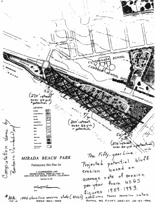
Barbara's Erosion Map
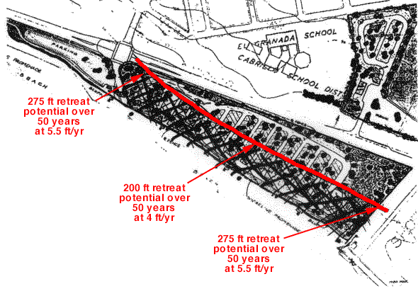
Barabara VanderWerf drew this map showing her estimate of the amount of buildable and unbuildable land on the ocean-side portion of the Mirada Surf property. [This has been retouched for the web. Barbara's original map is here, too (130K).]
Please note that the map Barabara used is from an earlier McCracken & Byers proposal to put houses on the west side of Highway 1. The current proposal is to leave this part as open space.
Barbara's notes on the map follow:
- The LCP (1992: Section 9.8) states that bluff and cliff top developments must have setbacks to assure at least 50 years of economic life.
- I have extrapolated rates of sea cliff retreat compiled by USGS between 1959 and 1983 at three cross-sections to predict the potential Granada Beach bluff line after fifty years as indicated on the accompanying sketch map (using the bluff line of the 1991 Mirada Beach Concept Plan).
- In 1996 USGS measured rates of sea cliff retreat at Granada Beach. Measurements indicate that the rate of shoreline erosion has not significantly diminished. In other words, Granada Beach bluffs continue to recede at more or less the same average yearly rate of between 3.5 and 4 feet, depending on cross section. This also means that with 13 additional years of erosion from 1983 to 1996, the 50-year line has moved closer to Highway 1 than indicated on the accompanying sketch map.
- I suggest that interested persons demonstrate the potential 1996 fifty-year line on-site. Stand on the beach bluffs near the southern property line of the western parcel. Pace off along the property line the 3.5-to-4' (more or less) average yearly erosion rate x 50.
- ***Please note that the 50-year line is a prediction based on historic and current USGS erosion rates. It is not a certainty. The accompanying map is a sketch map, not a precise rendering.***
- ***Please note that I have extrapolated from USGS data. USGS has not made nor participated in any of these extrapolations.***
- ***Please note that spatial constraints on the southeast corner of the property need to be identified: access, Caltrans Highway 1 easement, utility easement, coastal trail easement.***
 Back to Mirada Surf Main Page